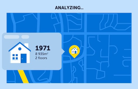
Single View of Client
Accuracy matters. It starts with data and specifically “addresses.” It’s the starting point of knowing your customer and address management solutions will accurately locate potential policyholders to better understand the risk that their location might expose. Identify products already sold or can be sold to policy-holders. Make data quality a priority.

Market Research
Using spreadsheets and standard business intelligence tools just don’t provide the insights that geospatial solutions will reveal. Visualize, analyze and target new policyholders using geoenriched data. Increase conversion rates and reduce churn. Find business opportunities in new markets and ultimately increase your market share.

Telematics
Usage-based auto insurance paves the way for new underwriting models that asses individual driving behavior. Use geospatial technology to map daily driving behavior based on speed, route, distance to work or home. Telematics data enriched with geospatial data such as road conditions, speed limits or weather will improve underwriting policy and improve risk management.

Catastrophic Event Planning
It’s impossible to detect when catastrophic events will occur. In areas impacted by natural or man-made disasters, use geospatial solutions to map customers in the impacted areas and direct field service personnel to the right place at the right time. Direct marketing activities away from impacted areas so as not to further annoy existing customers. Use GIS to conduct post-event analysis using aerial imagery to assess property damage and look for other perils that might impact underwriting policy.

Underwriting and Pricing
Correctly identifying risk to accurately underwrite policies and establish pricing guidelines is a function of good quality data. Geospatial solutions provide access to specific address data, claims history and additional data such as building type, property ownership and construction materials. These data can be factored into better models leading to better pricing. New data sources from telematics, wearables, and smart homes will contribute to the understanding of personal risk factors and exposure.

Claims Management
The moment of truth arises quickly in the insurer-insured relationship when a claim is filed. Take advantage of geospatial technology to determine claim history and events that may surround an individual property address. Find equitable solutions and improve your claim management process. It will inevitably lead to a better customer experience.

Fraud detection
Make geospatial solutions your weapon against fraud. Map unusually high policyholder claims locations; determine agent claims versus reported incidents and identify these incidents to historical claims data. Geospatial analysis leads to identifying unusual trends faster and visually detect irregularities. Protect your company from the economic consequences of fraud.