![]()
Get an easy-to-use GIS tool, allowing you to edit and map your geographic data.


MapInfo Pro, developed by Precisely, is one of the world’s most trusted desktop geographic information system (GIS) solutions. Designed for analysts and organizations that rely on accurate location intelligence, it combines powerful geospatial analysis, advanced mapping, and seamless data integration in one intuitive platform.
Whether you need to visualize complex datasets, optimize territories and site locations, or connect your workflows to the cloud, MapInfo Pro gives you the flexibility and performance to transform raw data into actionable insights. With a familiar Windows interface and support for a wide range of raster, vector, and database formats, it empowers both new users and experienced GIS professionals to make smarter, faster business decisions.
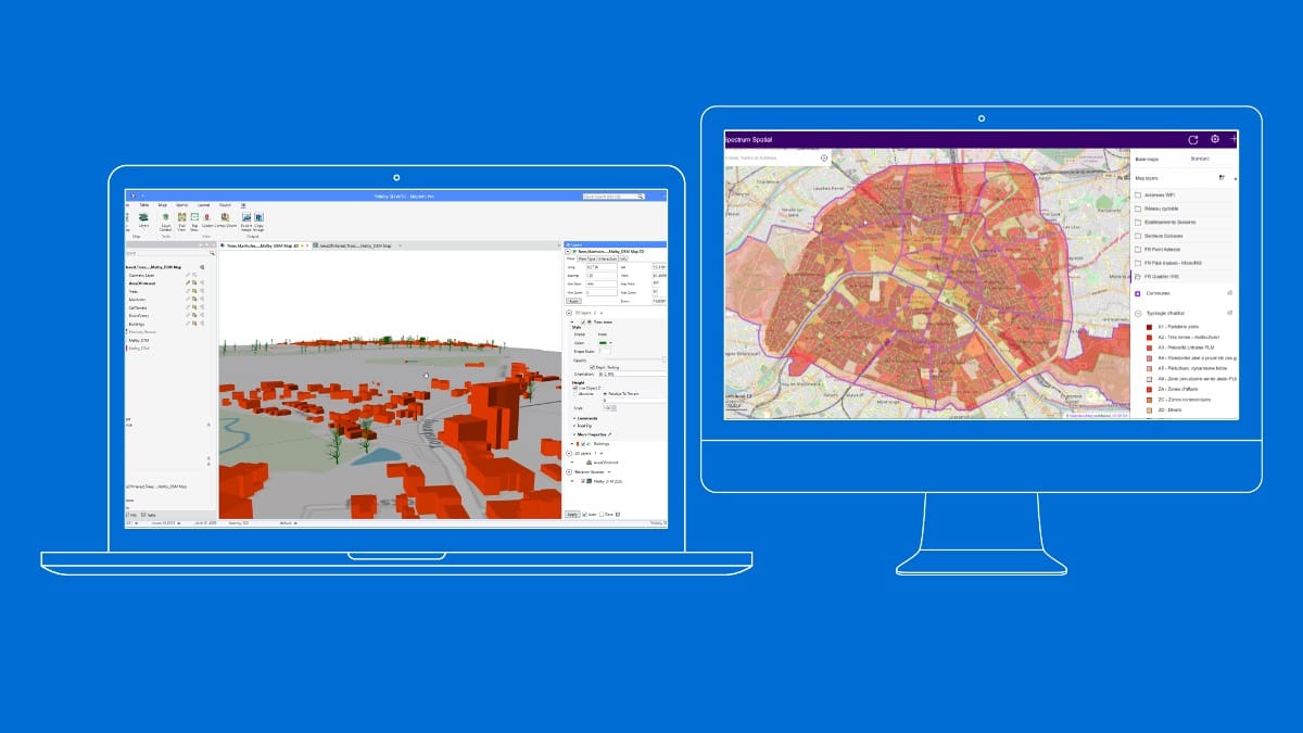
MapInfo Pro provides thematic mapping, spatial querying, raster data manipulation, and map layout. It is a 64-bit, highly performant solution with a familiar Windows user interface. Users can import data from many sources, vector or raster, and immediately begin to tackle any level of GIS project.
MapInfo Pro is designed with an intuitive Windows-based interface that makes it easy for new users to get started with GIS projects. You can quickly import spatial data, visualize it on a map, and start exploring patterns without requiring advanced technical expertise.
Create professional-grade thematic maps, customize styles, and design cartographic layouts that clearly communicate insights. MapInfo Pro enables you to move from raw data to polished visualizations that support decision-making across your organization.
Precisely and Korem’s professional services ensure your teams are fully supported through onboarding, training, and ongoing assistance. Whether you’re new to GIS or looking to expand your expertise, you’ll have access to the resources you need to maximize the value of MapInfo Pro.
MapInfo Pro connects directly to cloud platforms such as Snowflake, allowing you to edit, analyze, and synchronize spatial data in real time. Work online with live datasets or offline with local copies and push updates back to the cloud effortlessly.
Bring together raster imagery and vector datasets within the same desktop GIS solution. This flexibility ensures you can manage and analyze multiple data formats without switching tools, streamlining your workflows.
MapInfo Pro natively integrates with MapMarker geocoding and Precisely’s GeoAPIs to enrich your spatial datasets with accurate location data. This makes it easier to standardize addresses, improve precision, and enhance your analytics with location intelligence.
For experienced GIS professionals, MapInfo Pro delivers powerful geospatial analysis tools. Run complex queries, overlay multiple datasets, and uncover patterns that support strategic decision-making across industries such as telecommunications, retail, energy, and logistics.
MapInfo Pro includes a native connector for Snowflake, designed to simplify geospatial data integration between your desktop GIS and the cloud. This connector enables effortless, bi-directional data exchange with the Snowflake Data Cloud, no SQL or Python expertise required.
With this integration, users can access and visualize spatial data stored in Snowflake, edit it directly in MapInfo Pro, and push updates back to the cloud in real time. Work seamlessly with a live connection for instant collaboration or download a subset of data for offline productivity without losing synchronization.
By connecting MapInfo Pro to Snowflake, organizations can eliminate data silos and ensure that their geospatial analysis is always based on the most up-to-date information. This streamlines workflows, improves decision-making, and reduces the technical barriers typically associated with large-scale data integration.
Watch our on-demand webinar on MapInfo’s Snowflake Connector to discover how it can be used to optimize sales territories, manage high-density site locations, and refine customer insights.
Enterprises make critical decisions every day based on the location of their customers, assets, and infrastructure. To ensure accuracy and efficiency, they need reliable GIS software, expert guidance, and ongoing support.
By partnering with Korem, you gain more than just access to Precisely’s MapInfo Pro you gain a strategic ally who ensures that your GIS solution delivers measurable business outcomes. Korem’s team of geospatial experts helps you deploy MapInfo Pro effectively, integrate it with your existing systems, and connect it with cloud environments such as Snowflake.
With Korem, your teams can move from raw datasets to actionable insights faster. From data import and map creation to advanced spatial analysis and cloud integration, we ensure MapInfo Pro is tailored to your workflows. And with our training and support services, you can maximize adoption, reduce learning curves, and get long-term value from your investment.
The cost of MapInfo Pro depends on the type of license you need (single desktop license or simultaneous access), whether you choose a 1-year or 3-year license, as well as any additional services such as training and technical support. Korem can provide a customized quote based on your organization’s requirements and usage.
Yes. A 30-day trial version of MapInfo Pro is available through Korem so you can test its performance, interface, and compatibility with your datasets. This allows you to evaluate the software’s capabilities before making a purchasing decision.
MapInfo Pro is widely used across industries such as telecommunications, retail, finance, insurance, energy, transportation, and government agencies.
Korem also works with numerous school boards that use MapInfo Pro to optimize bus route mapping, ensuring not only greater efficiency and cost savings but also safer routes for students.
Its flexibility makes it suitable for any organization that needs to analyze spatial data and make location-based decisions.
Absolutely. The latest version of MapInfo Pro includes a dedicated Snowflake Connector, which allows you to access, edit, and synchronize spatial data between your desktop and the cloud in real time. This eliminates data silos and ensures you are always working with the most up-to-date information
Yes. MapInfo Pro offers an intuitive interface for new users, while also providing advanced spatial querying, thematic mapping, and complex data integration capabilities for experienced GIS professionals. This balance makes it a versatile solution for all levels.
Yes. As a Precisely partner, Korem offers complete onboarding, training programs, and dedicated support to help your teams quickly adopt MapInfo Pro. Our experts provide guidance at every stage, from deployment and integration to long-term optimization.