![]()
Perform a host of geographic, geocoding, and analytic functions with global administrative boundaries.


Regions and sub-regions are divided in many ways around the world. This organization can vary from nation to nation and even internally within the same country. World Boundaries Premium represents the political and administrative hierarchies within all existing countries in the most consistent way possible so that all places have a relevant name and boundary.
World Boundaries Premium thus provides comprehensive coverage of the world’s administrative boundaries combined with neighborhoods, suburbs, land use, and postal zones for over 200 countries and territories. This data is obtained from multiple sources and is represented with a unique file and table structure for ease of use.
Boundaries enable users to perform a multitude of geographical and analytical functions, such as visualizing and manipulating data for mapping or linking enterprise data to accurately locate customers and stakeholders. They also provide extensive support for forward and reverse geocoding, geotagging, and geofencing.
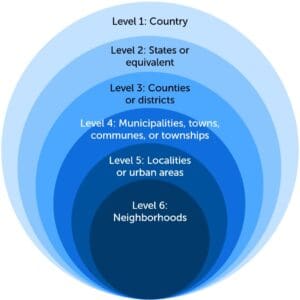
Level 1: Countries
Level 2: States or equivalent
Level 3: Counties or districts
Level 4: Municipalities, towns, communes, or townships
Level 5: Localities or urban areas
Level 6: Neighborhoods
World Boundaries Premium is available in two versions: Display and Geotag.
This dataset contains all boundary polygons for each administrative level. By providing data that can be viewed at separate levels, this dataset can be used as a basis for performing various types of analytics.
This dataset is a flattened adaptation of the Display version and contains only the most granular level available for each location. It allows for faster processing, for example, when performing reverse geocoding.
The World Boundaries Premium product also contains object layers and additional tables for:
by
![]()
Enrich your existing data with ready-to-use administrative and industry-specific boundaries to perform territory analyses.
by
![]()
Target your marketing and social media audience by location, and simplify property assessment.
by
![]()
Rely on updated ZIP Code tables listing all unique U.S. ZIP Codes boundaries and points to improve your geocoding.