Bell

Bell Efficiently Plans its Wireless Network with Korem

Summary

blue icon profile picture and description

The client

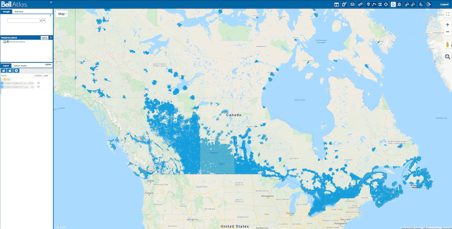
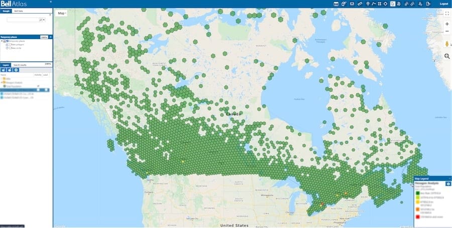
Bell is Canada's largest telecommunications company providing advanced wireless, Internet, TV, smart home and business services over their world-class LTE and fibre networks.

blue exclamation point in triangle

The challenge

Bell needed to find a replacement for their current geospatial solution that reached the end of life and did not meet their growth strategy.

Blue circle with a check icon

The result

Korem developed a custom visualization and analytics geospatial platform that can contain 75% more data while reducing the data publishing time by 95%.

Play Video

Download the Bell case study

The client

Bell logo for GIS telecommunications

Bell is Canada’s largest communications company with more than 22 million residential, business and wireless customer connections across every province and territory.

As Canada’s broadband leader, the wireless planning department is essential to keeping the business thriving. The team is responsible for analyzing vast amounts of network data to maximize capital investments in wireless infrastructure. “Being able to see the various types of data and to integrate each in a fast and robust way is a huge focal point for my team,” said Lance Taylor, the team’s manager. “It helps us to plan our investments more efficiently.”

Additionally, with the shift from LTE to 5G, it is no longer just about having the fastest network or the largest coverage area. The build-out of 5G networks brings an entirely new ecosystem of connected devices and with that comes unique challenges. The wireless planning team needs to understand how this changes the way they offer broadband services. For that, a powerful geospatial tool is required to analyze where it is best to expand their 5G footprint, improve network densification or make additional investments that support this wireless rollout.

The advent of 5G will also drive the need for highly accurate location technology. The challenge for carriers, then, is dealing with the unprecedented impacts of streaming services and an interconnected world of sensors, vehicles and people. By migrating to a modern system, Bell will be best positioned to win the race to 5G, poised to successfully test and incorporate field, assets and population-centric information at scale. This, in turn, will lead up to a smooth, steady launch of 5G products and services giving Bell a significant competitive advantage and more importantly, satisfied and loyal customers.

The Challenge

The Limitations of an Outdated Geospatial Platform

The previous solution, Google Earth Enterprise (GEE), was a geospatial platform widely used by the wireless team, including frontline engineers as well as senior executives. It was an essential day-to-day tool to answer questions such as “where are we adding 5G” and “where are subscribers receiving adequate coverage.”

However, functionally, the tool was pushed to its limits in terms of the volume of data that could be processed and the response time from servers. Bell had trouble displaying complex data and each new data layer created publishing delays that were unacceptable.  

Moreover, the GEE platform had stability issues that prevented hundreds of frontline workers, call center support staff and technicians from having access to the information they needed to do their job.

"When you think about an IT team, their number one goal is to strive for people to have information they need to do their job. And that wasn’t the case sometimes."
– Lance Taylor

Apart from those functional deficiencies, Google deprecated GEE in 2017 which meant that Bell was carrying risks associated with using legacy technology. The platform support was about to expire, and Bell was exposing itself to potential security issues. Maintaining legacy systems can be difficult because there is a lack of understanding about how they are run, and it may be difficult to integrate with newer technologies as there may not be sufficient demand for the integration technology. Over time, the system may eventually become more expensive than replacing the hardware and software. To add to this, a lack of security patches within older systems may lead to vulnerabilities and this could put the system at risk of being compromised, ultimately reducing profitability.

These challenges rendered the tool outdated, leading Bell to quickly evaluate its options and determine their evolution path.

The solution

A Custom Solution to Meet Bell’s Needs

As part of its strategic consulting service, Korem evaluated the corporate needs of Bell during this transition period. The mandate was clear: position Bell for growth and propose a more current, secure and scalable technology stack.

Bell’s engineering team was using MapInfo Pro, the desktop mapping solution from Precisely. Since all coverage models were built around a MapInfo Pro ecosystem, it made sense to use Spectrum, another Precisely data management and geospatial solution, as the platform base. By choosing Spectrum, few integration challenges were expected.

Once the platform was determined, Korem provided the necessary expertise for Spectrum to make sure it corresponded to Bell’s business needs. “Korem’s developers are very capable and the staff understands our business needs. It’s not just about how cool a widget you can build; it’s about having the right widget at the right place at the right time. That’s what Korem understood and made valuable recommendations, “ said Lance Taylor.

Korem’s expertise in custom software development supported Bell’s internally developed tool known as “ATLAS.” All GEE features or their equivalents were maintained to ensure continuity in this new GIS visualization and analysis platform.

"What I am very appreciative of is the fact that we are not taking some off-the-shelf solution and then just bolting it on a server and say here you go. There were some options out there that we entertained that were like that. The kind of one-size fits all but doesn’t do all what you need it to do. That’s where this platform really stands out. The ability to custom tailor to our needs and a true DevOps kind of agile growth."
– Lance Taylor

featured services

Bell Uses These Korem Services

Korem's Strategic Consulting Services

Management Consulting

We provide business and technology perspectives to develop an innovative geospatial roadmap that will create value for your organization.
learn more

Korem's Contract Advisory Services

Contract Management

We give you access to the best geospatial providers for which we already have negotiated the best prices and contract terms.
learn more

cylinder pie chart with a quarter cut out

Data and Analytics

As the most diversified geospatial expert team in North America, we can bring your team quickly up-to-speed or extend your team's capacity.
learn more

Korem's System Integration Services

System Integration

Whether you are looking at geospatial enablement or for fully customized application, we deliver on time, on budget and on target.
learn more

Korem's Managed Services

Managed Services

We complement your in-house IT operations to accelerate your time to value and maintain your geospatial solution in a cloud or hybrid environment.
learn more

Key results

75%

more data ingested

95%

faster data loading

15hrs

per week saved in maintenance

The outcome

Outstanding Autonomy and Productivity Impacts

This new custom solution yielded many benefits. “ATLAS is able to ingest 75% more data than the previous solution. In fact, it can now support one terabyte of raster data, which was previously not possible. The publishing time has drastically reduced from five days to only 1 or 2 hours“, said Mauro Poblete, the Seamless Planning & Geospatial Analytics Manager. This generated significant time and productivity gains.

The data is now more current and there are daily, automatic updates. Data integration is more efficient and the result is fewer errors, thereby saving at least 15 hours per week that had been dedicated to data maintenance, verification and correction.

Because ATLAS was built with the different types of end users in mind—which are not always GIS specialists—people can now work more autonomously. The combination of an easy-to-use interface and the capacity to add internally generated data layers and analyze them as needed, gave the wireless team operational freedom. “By giving the wider user base more access to layering and making their maps in the way they wanted it, it saved a lot of time, “ said Lance Taylor.

The seamless planning and competitive analytics team, who were previously receiving more than four thousand map-creation requests per year, is now able to direct them to the ATLAS self-servicing platform.

A Year of ATLAS in Numbers

60k

sessions/year

78k

page views/year

9,900

users/year

"The tool has been built in such a way that it’s easy for anybody to pick it up and start using it. They only need to go to the page, log in and in a couple of minutes, they are flying through adding their own layers, making comparisons and other types of geospatial analytics."
– Jakub Stroinski

This autonomy and operational freedom are such that the tool is now used by other departments. Sales and marketing, for example, are using ATLAS for their 5G rollout campaigns. The possibility to add data layers, such as geodemographic data, has made ATLAS a true analytics asset for many of Bell’s departments.

the future

New Capabilities for the Future

Over time, ATLAS has helped Bell discover capabilities that they didn’t know they needed. With ATLAS’ flexibility and scalability, Korem’s team has progressively been adding many capabilities. With those, Bell was able to discover network performance issues and weak spots. They also realized how important it was to their frontline workers to have very detailed, real-time signal strength information. Now, anywhere in the country, the ATLAS users can zoom in and load files that are pregenerated in the server, allowing them to see exactly what the RSRP is for that given location.

ATLAS has generated such enthusiasm and praise that, so far, employees are coming up with new ideas for capabilities that could be added. “It creates an interesting new problem for us because now, we have to focus on adding more storage and figuring out use cases or new features that we need to prioritize in our development cycle,” said Jakub Stroinski.

"We don’t have a final product, we’ve been adding things every month, every year. Every time I got into ATLAS, there seems to be a new feature. Very specific custom-tailored features for our work. That you can’t get off-the-shelf."
– Lance Taylor

CHATWITH US