Creating a Data-Driven Organization to Master Mixed GIS Environments
January 6, 2021

One Size Does Not Fit All
We often say that one size does not fit all, because we believe that one geospatial technology, no matter how comprehensive, will not satisfy every location-based task. Some are better at geocoding, while others are better at 3D visualization or at remotely-sensed data analysis. It then becomes difficult to choose the right solution for location intelligence. While some organizations may try to convince themselves that their vendor has the right technology mix, it is simply not the case. If the only tool you have is a hammer, then everything starts to look like a nail.
In reality, many companies do not have GIS experts and don’t need an advanced GIS solution. Some have thousands of business intelligence users and knowledge workers who are not GIS experts but use a BI tool that has integrated basic geospatial technology. They required an intuitive environment with good performance. While still other departments may need more advanced geospatial functionality like 3D data manipulation.
But, as a result, this ostensibly creates the challenge of working in mixed geospatial environment.
→ free on-demand webinar on how to tackle a mixed GIS environment
The Challenge of Mixed Geospatial Environments
Having distinct needs, organizations will often use vastly different geospatial software technology. From a solution architecture perspective or a CIO’s perspective, it would be more efficient if these departments consolidated onto a single geospatial platform. Why maintain separate systems that would basically perform the same tasks?
But this is simply not reality. Companies do maintain separate legacy systems that they find hard to “kick out.” There may be several reasons for this including the fact that certain software solutions perform very specific tasks and are essential to certain workflows. Of course, internal politics plays a role in keeping certain software tools or selecting vendors. But there must also be consideration given to the experience of the team that has used one system and therefore has no desire to learn a new solution. However, the result is that many organizations far underestimate the complexity of maintaining an ecosystem of GIS, BI and spatial databases.
Geo-enabled solutions
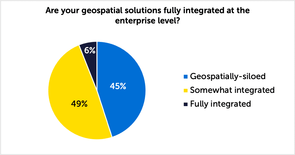
Since working within a mixed geospatial environment is a more frequent reality than consolidating and maintaining geospatial information within a single GIS environment, organizations need to make sure that these systems are interoperable. In our Mixed GIS Environment webinar, we’ve asked how many of of our attendees had fully integrated their geospatial solutions at the enterprise level and only 6% answered that they have.
It would be preferable to have a “geo-enabled” system of record, like an Oracle or SAP database environment, which already supports geospatial primitives and can link to the geospatial software solutions chosen to be performant for a given use case.
Data interoperability is important. Business solutions and core geospatial technology should and must communicate with a central geospatial data hub. A true system of record, with clear data governance, must be maintained. As more dynamic data pour into a geo-enabled environment, such as data streaming from IoT sensors and other connected devices, data quality and integrity must be maintained.
As is the case with many situations, the use case often dictates, or should dictate, the chosen software application so that it is fit for purpose. This may mean choosing solutions and data that are not necessarily compatible with the “incumbent” GIS software.
Data Governance Is Key to a Data-Driven Approach
Let’s consider a simple question. Can a single, GIS software vendor support all your geospatial needs? The answer is likely, no. But there is a difference between being a software-driven organization and one that is data-driven.
Data-driven organizations are:
- 23 times more likely to acquire customers
- 6 times as likely to retain customers
- 19 times as likely to be profitable
(Source: McKinsey Global Institute)
As a best practice, data governance (DG) and data centralization is a very important stating point. Large companies sometimes fail to recognize this as a priority especially as data volumes increase.
Wikipedia defines DG as a “concept … that enables an organization to ensure that high data quality exists throughout the complete lifecycle of the data, and data controls are implemented that support business objectives.”
As an example, one of our customers has centralized in an Oracle Locator database providing an easy way to communicate between three separate, in-house GIS solutions. The priority, then, is more about data governance than about technology governance. These questions may arise:
- Who owns the data?
- What is the system of record?
Again, data governance is the key.
As another example, the great majority of banks maintain their mainframe environments and do not intend to migrate to a different, more updated or cloud-native environment. They are maintained as the system of record and merely synchronized to other updated IT infrastructures.
Next Steps
Questions will arise as to when it becomes necessary for my organization to consider a different direction. Let’s look at a few questions that will become a decision point as to when to seek advice and counsel:
- Does the organization need to harmonize business strategy and geospatial solutions?
- Does the organization need to benchmark geospatial solutions in order to make the best choice?
- Does the organization consider data quality and geocoding accuracy a key solution to improve business processes?
- Does the organization need to consolidate geospatial technologies?
- Does the organization need to integrate disparate data types and formats?
- Does the organization lack the institutional knowledge or have a lack of internal resources to help determine the best geospatial solution?
While these questions are challenging, they should not prevent the organization from implementing a strategy where a mixed geospatial technology environment is already in place. Quite the contrary. A mixed environment can be successful if the right focus is placed on becoming a data-driven organization.
