What’s New in Precisely MapInfo Pro v2019
January 9, 2020

Precisely, formerly Pitney Bowes has made significant changes in recent versions of MapInfo to make the application more robust, easy to use and responsive to market needs.
Migration to the 64-bit architecture, ribbon-based interface, the integration of the Python language, as well as the extended tables format, which eliminate the 2 GB size limit, have a direct impact on the everyday use of the software. Rounding out the list of changes, the Multi Resolution Raster (MRR) format is making headway in the market since other major software providers like FME and Alteryx are now supporting it out of the box.
With that, let’s take a look at the features of the 2019 release and see how users can take advantage of them.
Meet the new SQL Window
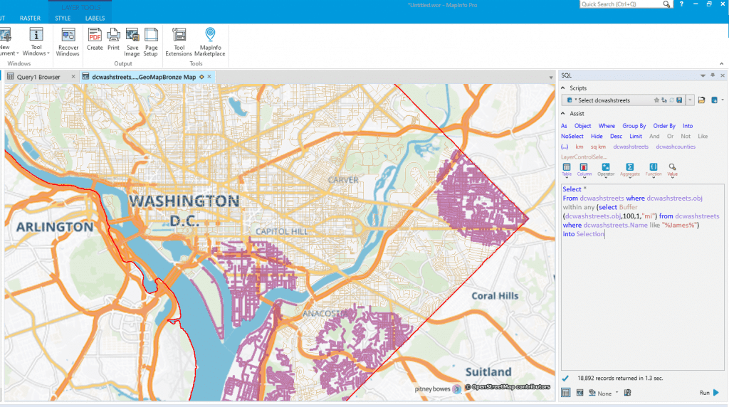
If you are a longtime user of Precisely MapInfo, you may have had a love–hate relationship with the SQL Select dialog box. New users may find it complicated at first, while seasoned users may feel limited during advanced operations. If you are seeking an interface compatible with the SQL language, you should definitely have a look at the SQL Window. This new interface allows you to type in (or use CTRL-Space for autocomplete) the sentence instead of decomposing it in separate text boxes. You can then copy statements from other applications and paste them directly into MapInfo. In addition, insert, update and delete statements can be run from that same interface, and the number of records returned can be set (limit) for a better control over your datasets.

Leverage heatmaps for a better view on your geospatial data
While raster functions are part of Precisely MapInfo Pro Advanced, the 2019 version is bringing heatmaps to all license levels. The heatmap’s styling is particularly well suited when we need to show aggregated data. Using zoom layering, you can show aggregated data on a small scale (zoomed out) and render data using standard styling at larger scales to facilitate understanding at each level. Adding a heatmap layer to an overview is another good example of the new heatmap functionality, since it adds insight about spatial repartition. Available from the Map tab, you can create 4 types of heatmaps, Standard, Detailed, Smooth and Optimal. This choice is essentially driven by the level of resolution required.
Edit and execute code with the Python console window
You can now script add-ins and interact directly with your MapInfo projects using Python. Users are no longer restricted to using only the MapBasic language when programming custom MapInfo Pro applications. The Python console allows users to edit and execute code directly from MapInfo Pro. No additional actions are required as MapInfo Pro will automatically install the Python environment. Python scripts that interact with MapInfo Pro can also be executed from the command line without having an open instance of MapInfo Pro, which allows greater automation. Moreover, users will be able to leverage the many available Python libraries whether they are geospatially-oriented or from other general libraries. The possibilities are limitless.
Experiment with the LiDAR surface tools
Create continuous surface maps from your LiDAR LAS/LAZ data by using triangulation techniques with the new LiDAR Surface tool. Users will be able to select the triangle size, the cell size and apply filters based on the classification of your point cloud data to help generate the correct raster size for your applications. Also, the new Tree Canopy tool can be used to calculate basic statistics such as coverage percentage, thickness and tree canopy height.
Rise of the Precisely MapInfo Marketplace
One of MapInfo’s differentiating factors is that it keeps it simple for the users. The Tools Extension window lets you decide which functions you need to load once and which you need to load during each session. Located in the Tools section of the Home tab, the MapInfo Marketplace is a new repository that you can use to add tools built from the MapInfo developers, partners or the community.
Let’s have a quick look at a couple of tools from the Marketplace. First, the Street View tool should be of interest to many users. While we’re all used to working with Google StreetView, accessing it from an external application like MapInfo requires extra clicks that are eliminated using this tool. The workflow is quite simple: you choose the tool, select a location and specify the direction. Windows Explorer will open automatically and set the view port to your selection. We like this implementation since it is aligned with Google’s terms and conditions. Finally, the MapInfo2Excel tool lets you create Excel files with table data, maps and reports quickly and easily. You can visit the MapInfo Marketplace to learn more about the available tools.
Want to have a say on which features to implement next?
These new features have been chosen from the Knowledge Communities website, where users propose and vote for features they would like to see implemented in MapInfo and other products in the Precisely’s Location Intelligence stack. Please join the discussion and help other users leverage LI tools and processes, and propose new features for MapInfo, the Spectrum Technology Platform and the rest of Precisely’s Location Intelligence product family.


