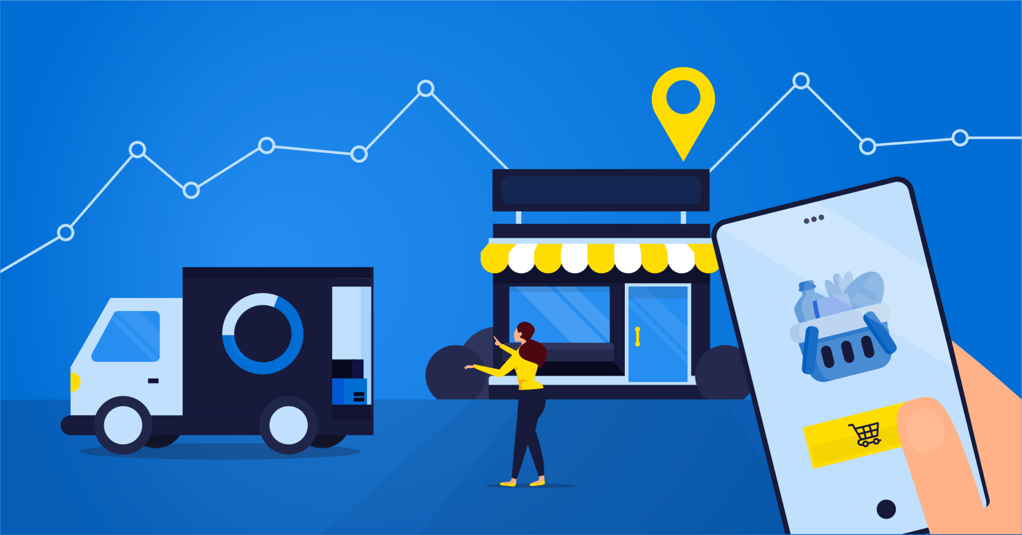
How Retail Industry Data and Geospatial Analysis Are Used to Gain Customer Insights and Drive Growth
July 17, 2020
Location represents one of the critical success factors in the retail industry. Geospatial data and technologies are involved at all stages of the retail business, from site selection, to delivery to the customer. Each step requires a geospatial component to plan activities and make superior decisions at three critical levels: strategic, operational and experiential.
How to Build a Good Retail Strategy
Who are we selling to or trying to sell to? Whether you are a new business or an established one, it is important to know who will be buying your products. Once you know this, you can establish an appropriate territory management strategy and make informed decisions about site selection.
It All Starts with Market Research
Understanding the profile of your potential customers and current customers is crucial for a good retail strategy. The better a business understands its customer base, the better it can serve it. With geospatial data, you can segment your market and create buyer personas that will help you define your target market and market size.
There are many different factors that can influence the purchase and should be considered when performing market research for the retail industry:
- Demographic data
- Spending habits
- Customer behavior
- Accessibility
Since every purchase takes place somewhere, analyzing geospatial data helps retailers understand how these elements play a role and influence the purchase. Loyalty programs are an efficient way of collecting customer location data that can help in the market research process. As an example, Korem has enabled Shell to leverage its customer loyalty data by automating the analysis process rather than doing it manually on a site-by-site basis. The energy company was then able to achieve net new margins of €3.3 million for Germany alone within only three months. However, when loyalty programs are not available, asking customers for their address or postal code becomes important in order to determine the locations with the most clients.
Additionally, geospatial analysis, such as traffic analytics, can help you gather data on the store performance, the market conditions, and the customers’ behaviors in a given area. Indeed, by analyzing mobility data, such as vehicle traffic data and foot traffic data, retailers can compare changes in traffic flow for sales forecasts, improve competitive intelligence on brand awareness and success factors, and create an accurate picture of consumer demographics and behaviors. It is then possible to forecast their demand by aggregating all this data.
According to The Business Application Research Center, companies usually use 8 different data sources (5 internal, 3 external) for decision-making. A good geospatial solution provider has experience with data integration and has access to many different dataset formats. They also have significant experience in location intelligence to help you build workflows to automate the retail data analysis, enabling you to visualize the relevant insights.
Territory Management
To manage a territory, the first step is to create a trade area defining the target market from which to source your customers. It is important that the trade area is defined according to the location of your potential customers rather than geographic boundaries.
With the territories outlined, the next step is to decide if the location is appropriate for a corporate store or a franchise store when necessary. Making sure the territory is adequately covered is the main reason for territory management, but franchisors may also use territory management for legal reasons. Having a clear territory defined in each franchisee contract will reduce the risk of cannibalization as well as territory and marketing disputes between franchisees and corporate stores.
Once a territory management model with clearly defined metrics based on the available geospatial data has been established, it is easy to modify trade areas. By moving the boundaries to adjust the target market for promotions and marketing, it is possible to fine-tune and balance one or multiple adjacent territories. With the search criteria in place, testing the environment by moving boundaries, might highlight opportunities to expand one franchise territory in size, while reducing another.
Take Advantage of Geospatial Data for Your Site Selection
Long before e-commerce existed, the location of a store had a profound effect on its performance. In a world where e-commerce is becoming more and more prominent, either with the arrival of new technology to facilitate online shopping or because of unforeseen events such as a pandemic, location still remains of great importance. This is why selecting the right geospatial data is of the utmost importance when it comes to site selection.
There are two types of site selection; one that involves existing store locations and a second one that analyzes the potential locations for a new store. Site selection with existing stores may result in recommendations for renovation, reconstruction, relocation, or closure.
The data gathered in the market research phase needs to be analyzed through a geospatial lens and geoenriched to optimize site selection. Location analysis for retail must take into account several types of data to find and select sites that will be the most successful.
Competition
In some sectors, competition is essential to make sure the location attracts more customers. Customers often want to visit several stores on a shopping outing, to enjoy the activity and see a variety of products. In that situation, stores benefit from proximity to each other and can even be complementary to each other.
In other categories, retailers may want to be as far away as possible from competitors and be in a separate area. Some supermarket chains, for example, will buy the most suitable locations, to stop competitors from having access to them, even if they don’t build on the site themselves.
Points of interest
Depending on your type of products or services, certain categories of points of interest might be beneficial for your site location. If you know that a specific customer segment is particularly interested in a POI (Point of Interest) type, it will help you map out the area containing the most of this POI. POIs can range from parking, transportation, business types, gas stations, hotels, or restaurants, among others.
Traffic
By knowing the level of traffic of a location and analyzing traffic patterns, it is possible to determine if the location would benefit from good customer traffic and when the peak times are. Heavy foot traffic and mobile traffic can also be used to check if the store has good visibility from the street and could easily generate curiosity.
Drive-time polygons
Drive-time polygons are essential to understand where the geographic limits of people most likely to shop at your store are. The ideal site location is in a drive-time polygon that contains the most people corresponding to your target market.
Industry-specific data
There are several other industry-specific data and these are equally important for site selection such as cost per square foot and legal restrictions.
Visualizing all this data on a map and having a geospatial enterprise solution makes it easier for real estate managers that are on-site, to easily spot site location opportunities and instantly synchronize the data with the office. By combining historical sales performance data with commercial data, it is then possible to forecast sales for each location and determine the ones that would be the most profitable.
While it may be difficult for an individual company to collect and understand this information, it is readily available to geospatial companies who have access to aggregated data, and expertise to interpret it.
Analyzing and Running Store Operations Smoothly
For a store to be successful, there needs to be a good geospatial marketing strategy in place as well as a good merchandizing strategy. Once those are clearly established, data gathering can commence. Just like during market research, geospatial data is important to keep on understanding the factors that contribute to the performance of your retail location. You can also compare your performance with the performance of other store locations.
Geospatial Data Contributes to Better Marketing and Merchandizing Strategy
The marketing strategy, the exact product mix, and merchandizing strategy may vary according to the information derived from geospatial data.
Depending on the location of the store, the featured products and how to present them will differ. The store layout may also be distinct from one location to another to encourage customers to move around the store on a predetermined route.
In an affluent area, you might look to mix and match high-profit products and branded items with the core items that people commonly come in for. In a low-income area, you might make it easy for people to find their staples and then merchandize the checkout area with a high-profit margin selection of sweets, as is common in convenience stores for example.
Chain stores can benefit from being able to compare sales between their stores in areas with similar demographics. If a store stands out in terms of profitability or inventory turnover, lessons can be learned and reproduced in other sites. Likewise, if a strategy is not working, analyzing a checkout basket against purchasing power might highlight trends for consideration.
The perfect example comes from an urban legend about beer and diapers. According to the story, a Walmart manager found out by analyzing the data that diapers and beer were often bought together on Friday nights. The hypothesis was that men with newborn babies at home, stopped by the store after work to buy diapers but were also tempted to reward themselves, with beer at the end of the week. By placing the two together, the sales increased.
By understanding the types of consumers and their behaviors in your area, you will be able to offer them products or rebates that are relevant to their lifestyle.
In an area where there is a high average household income, you can use price elasticity. Many people don’t look at the price up to a certain point so higher prices may not negatively impact the inventory turnover while generating higher profit margins (inelastic behavior). On the opposite, in a less affluent area, the same strategies may lead to customer churn as word gets out that the store is quite expensive (elastic behavior).
Accurately Evaluate Omnichannel Performance with Geospatial Analysis
Geospatial analysis of store performance is essential to understand what is working well and what is not, and then be able to adjust the retail, marketing and merchandizing strategy for each store location accordingly. Historically, a lot of professionals, such as fuel pricing managers, have relied on their experience and gut feeling to make decisions. However, with the increasing number of variables and competitors, geospatial data and analysis are becoming crucial to success.
Today, many stores offer multiple channels to their customers. In addition to traditional in-store transactions, they may take phone orders, sell online via e-commerce websites, and may even supply other stores at reduced margins.
This composition of business makes it more challenging to evaluate the sales performance of products and categories without considering the multiple channels. Omnichannel retailers need to have a detailed understanding of the interplay between online and offline touchpoints.
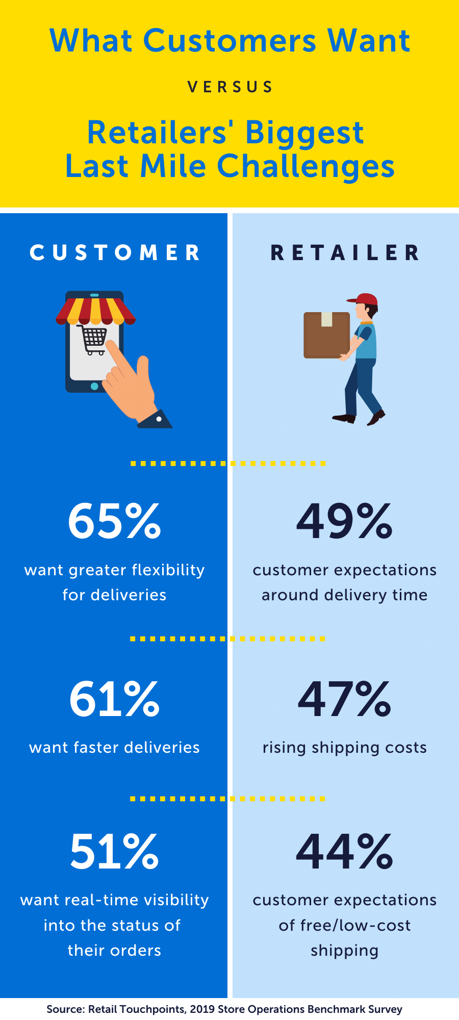
In a 2019 retailer survey, 36% of respondents said that aligning brick-and-mortar locations with digital channels is their greatest store operation challenge, compared to only 9% in 2018. However, the influence between the various channels can be significant. For example, on average, a person that shops in more than one channel spends 150% more than a single-channel shopper (Retail TouchPoints).
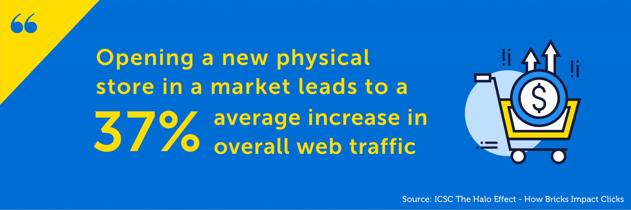
The relationship between bricks and mortar stores and online stores should not be overlooked either. The “Halo Effect” was explained by the International Council of Shopping Centers (ICSC). They discovered that opening a new physical store in a market leads to a 37% average increase in overall web traffic. This means that the store experience contributes to online shopping and vice versa.
Without the proper retail data analysis, it may be difficult to know whether sales are going well with some products because of great merchandizing and store design. Similarly, without online retail industry analysis, it could be hard to know whether other products are not selling well in-store because many customers prefer to buy them online.
Measuring store performance is hard, and the traditional tools that a retailer uses, such as reports from the Point of Sale system, are not designed to report on sales that do not take place at the sales counter. Because they don’t have the right systems, many companies are making decisions about the viability of stores without having the full picture. With the right retail analytics solutions and visualization software, it becomes easier to make good data-driven decisions.
Using Geospatial Technologies to Create Amazing Customer Experience
Consumers are becoming increasingly demanding and it has driven the need to shift to a customer-centric approach. Shopping experiences are no longer reserved for brick-and-mortar stores but extend to all channels and touchpoints a consumer can have with your brand. Hence the need to create a unified, seamless, and memorable shopping experience across all channels. The customer experience is also extended since, compared to a store purchase, an online purchase involves several additional phases before being in the hand of the customer. You have to know who will fulfill the order and what the most efficient way of delivering the goods to the consumer’s door will be, while also respecting the expectations of the latter.
Develop Customer Loyalty While Gathering Geospatial Data
Since customers now shop on multiple channels, it is important that the experience is as good on every channel. Using the right geospatial software makes it easy to create a 360-degree view of your customers. It helps centralize their behaviors and their purchasing information across all channels, which can be analyzed to identify purchasing patterns and trends.
Loyalty programs are a great way to populate your 360-degree view of your customers, in addition to creating a better shopping experience by recognizing and rewarding your regular customers. The collected data on a product or category level provides customer profiles and consumption habits but also allows you to associate it with their address. Querying data from loyalty cards allows you to compare customers who live near each other. Even within a territory that you have designated as your customer base, there are variations in different streets or blocks. With a loyalty program, you can analyze all of their interactions, compare them with other customers, with customer types, and develop a large portion of your business model. Loyalty data becomes very useful when the information is analyzed together with geospatial demographic data. You can then use this data to tailor promotions or keep customers informed on what matters to them which will keep them engaged with your brand.
GIS in Retail Industry for Effective Online Order Fulfillment
Using a location-based API from your geospatial provider, you can use type-ahead or fast complete tools, to ensure that the client correctly enters the address in an effortless way. Costly errors can range from wasting time on the phone to confirm information to delivering to the wrong address.
Another crucial part of the delivery process is choosing the right store to fulfill the order. Failing to choose the right store can result in the wrong estimate or longer delivery time and stocking issues, which will ultimately dissatisfy the customer. With geographic information system (GIS) technology in the retail industry, it is possible to automate order fulfillment by geocoding the address, locating it in the predefined trade area, identifying the nearest chain store available for delivery, and confirming that the items are in stock at that store.
The easier you can make the transaction for the customer, the more likely they will buy and come back to the site again in the future.
Reaching the Last Mile with Precise and Comprehensive Geospatial Data
Even if it is the last step before delivering the products, the last mile is just as important in the purchasing process and largely influences customer satisfaction. Customers have very high expectations when it comes to the last mile delivery and it is increasingly difficult for retailers to meet those expectations.
Because delivery is expensive, retailers need to find the most cost-effective way to achieve it. Using route optimization to plan the best order in which to make the deliveries in the least time and distance traveled is one way to reduce delivery time and costs.
The traditional “traveling salesman” solution used to be adequate for route optimization, but with today’s high level of traffic congestion, an urban route calculated without traffic information is a highly inefficient option. It impacts on the customer promise and expectation that orders will arrive within a specific time window. Many companies have had to change their delivery promise due to factors outside of their control, and would have benefited from traffic data to better predict the delivery time.
In an urban environment, predictive traffic, based on historic traffic congestion levels and travel times, can be used to plan an optimal delivery route. Historical traffic can also be incorporated into the equation to determine a maximum delivery time and to ensure that the expectation or requirement is achievable before the purchase is accepted. Some companies also offer real-time monitoring of the package to their customers, significantly increasing customer satisfaction. However, this kind of system requires a robust geospatial solution.
With services like Uber Eats, customers are developing an understanding that there are delivery costs, but also that they can have visibility over the location and status of their order. Customers are understandably raising their expectations of the level of service because they see what disrupters like Uber offer, and are often ready to pay extra for convenience.
Location Intelligence is a Powerful Tool for Retail Success
Geo-analytics for franchises in retail have a significant impact on the success of a store or chain. What works well in one location could ring the death knell in another one.
By understanding the persona of the ideal customers for a business model, and then running location analysis, it is possible to establish whether a site will be successful or not. Get it wrong, and it is unlikely that a store will perform, no matter how much you invest in stock, fixtures, and layout.
For an existing business, all of the elements in this article come together, allowing retailers to make smarter decisions. Nothing stays the same, and recent times are a good reminder that “Business as usual”, is not a solid foundation for growth or survival.
Technologies and systems are continually changing, and it becomes difficult to know and compare all of them. At Korem, we help retailers by sharing unique market perspectives and vendor-agnostic recommendations. We offer the most comprehensive and diversified geospatial solutions portfolio to meet the needs of our clients.
Location is so much more than the site your store occupies. Combining a thoughtful retail strategy, multichannel performance and predictive analytics for retail as well as a solid understanding of customer needs with geospatial technologies and geospatial intelligence is the foundation for modern retail success.
